Last year I was invited to join 3 friends on an adventure of a lifetime – fastpacking the TMB over 5 days.
Having spent time in Courmayeur last year, hiking and running the trails around there, fastpacking the TMB quickly became a bucket list item for me. It was a massive coincidence and simultaneous blessing to be invited along to tackle the famous Tour du Mont Blanc over 5 days.
Blog post series and links
I will fill out this section with links to detailed blog posts of each of the 5 days as I post them in the coming weeks.
This post will be a summary of the entire trip, containing shorter details and photos or highlights of each day. The posts that will be linked above will have more details and breakdowns about each day.
Fastpacking the TMB requires careful gear planning
Staying in refuges/gîtes each night means you can dial back the weight to carry a fair deal. You don’t need to carry a tent of course, and if you choose carefully, most refuges have blankets included. You’ll just need to carry the other things you’ll need during each long day of fastpacking.
Moving faster over the rugged mountain terrain means you should aim to pack light, as any unecessary weight will equate to more strain on your legs, increasing the potential for injuries or pain later on in the journey.
Pack decision
With that said, I initially planned to take my Aonijie 30L lightweight hiking backpack. However, after testing it out, fully packed on a short local hike with my kids, I felt the waist strap wasn’t comfortable enough for me.
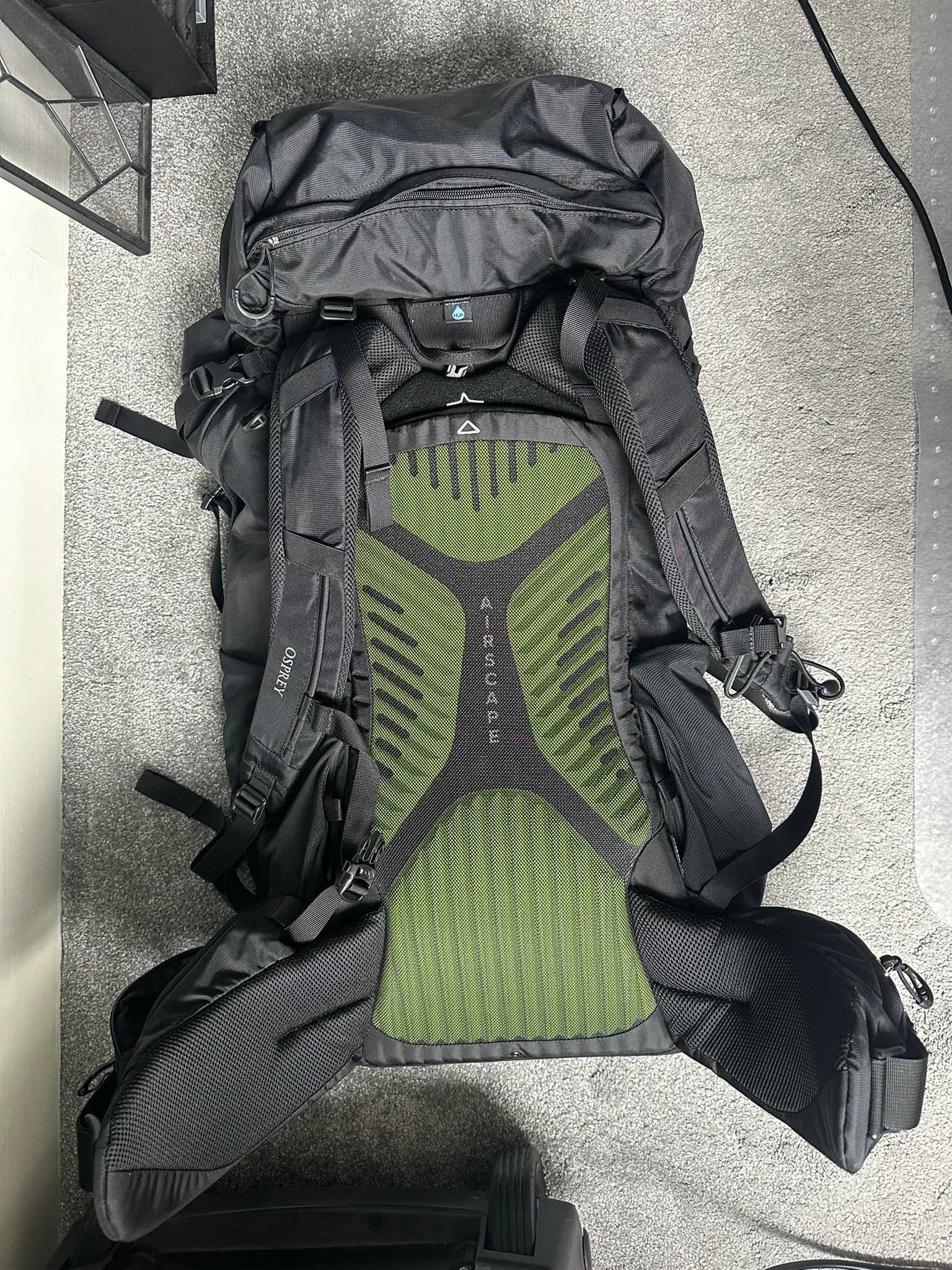
I ended up choosing my heavier, but far more comfortable Osprey Kestrel 48L pack instead. It has a comfortable waist strap, and good adjustable chest strap. It’s heavier (around 1kg just for the pack), but offers superior comfort for the shoulders due to the waist strap.
Speaking of which, the waist strap itself has two zipper compartments, which I used throughout the trip to keep my phone and DJI Osmo camera handy for photos and video. I also stored quick access snacks and ibuprofen in these (more on that later!)

My fastpacking the TMB detailed gear choice
- Salomon 2L hydration bladder. I stored this in the top zipper section of my bag, and only ever filled it to 1.25L (to keep my pack weight down).
- Black Diamond Carbon-Z trekking poles (these were essential)
- Montane waterproof cap (very light) in case of rain
- Trespass sleeping bag liner (essential for lightweight sleeping comfort and use on the beds which only have linen changed once a week)
- North Face hat
- Sunglasses
- Small water proof bag with essential charger cables for my phone and Garmin Fenix watch, painkillers
- 2 x 500ml soft flasks as backup
- Buff
- Bearhug knee braces (I have been struggling with some IT Band issues since my Rollin’ 100 mile ultra a few weeks ago).
- Patagonia running shorts
- 2 x lightweight, tech breathable t-shirts (Odlo and Adidas Terrex)
- 2 x merino runderwear undies
- 2 x pairs merino socks – use during the day, 1 x light pair of socks for refuge use
- 1 x pair merino long trousers – lightweight, and warm in the evenings and for sleep
- 1 x light pair of gloves in case of cold/wet
- Sol bivvy bag for emergency use
- Small bag with pre-cut k-tape, and some pre-cut blister treatment bits and pieces
- Odlo long-sleeve base layer, used once on a cold night, and in case of rain/emergency during the days
- OMM rain jacket (20000 waterproof)
- Montane synthetic down jacket (essential in late afternoons and evenings at the refuges)
- waterproof and warm beanie hat
- Small towel for showers each night
- Small bar of soap, toothbrush and toothpaste
- Sunscreen 50 SPF and body glide for reducing chafe in sensitive areas
- Euro plug adapter, and USB charger plug
- iPhone and DJI Osmo 2 camera for photos and videos (and of course comms!)
- Small bag of all bran cereal for extra fiber, and some basic snacks to start (PF 90 gel for emergency, rusks)
Gear and pack weight
My total pack weight with 1.25L of water added was 6.7 kg (kilograms). Not bad at all, and comfortable.
I would not recommend fastpacking the TMB with anything over 8kg.
Here is the Osprey Kestrel 48L pack I settled on using.
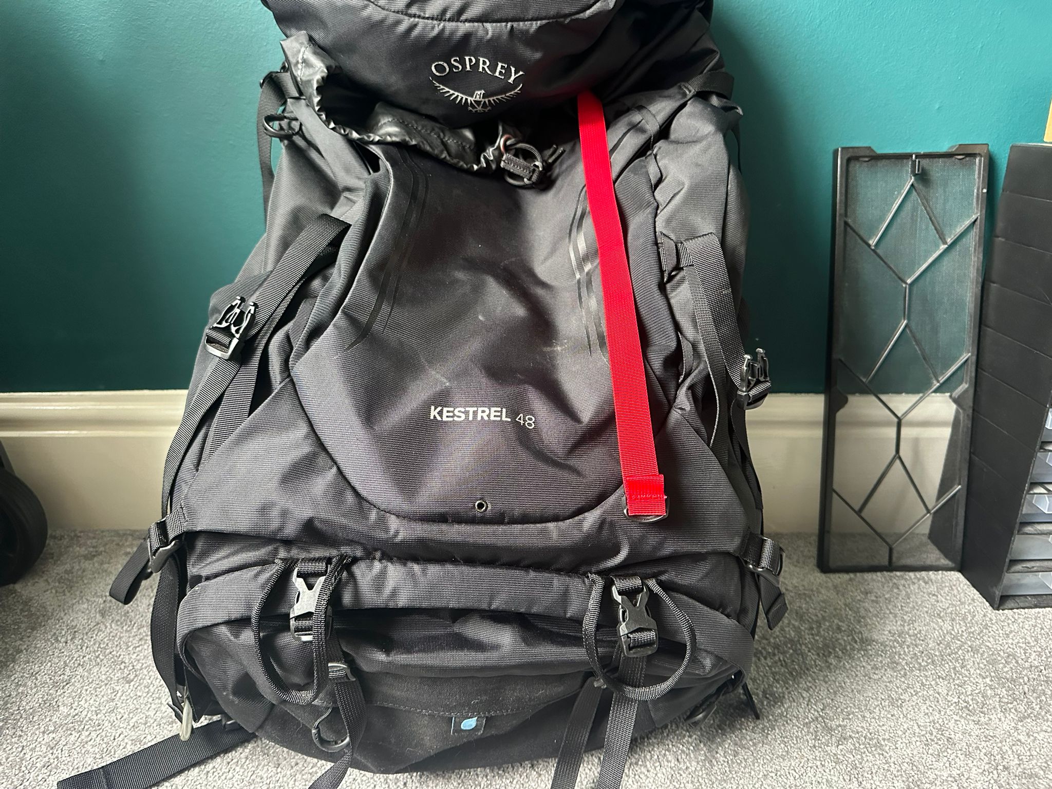
It was heavier than I needed (the other guys took 16-20L sized packs and had enough space). However, I was fine with the extra pack weight trade-off for extra comfort.
I was also able to run decently with this pack on. Tightening up the waist and chest strap was easy, and over the full TMB route, I did run many miles on the flat and down hill sections. The pack also had a built-in waterproof cover at the bottom, which came in handy on day 4 when we had some rain.

Fastpacking the TMB, a day-by-day breakdown
I joined good friends Matt, George and Jonny in Haverfordwest (Pembrokeshire, Wales) on the morning before our start, where we took Matt’s van across to Bristol airport. From there we flew to Geneva, and then took an Alpy Bus transfer direct to our start in Les Houche, France.
We would do the classic counter-clockwise TMB route, starting and ending at Les Houche.
We stayed the first night in Gîte Michel Fagot, right next to the starting arch of the TMB.
Dinner was a fairly simple sausages along with a really tasty rice and aubergine, along with a small beer to celebrate our arrival.


We donned our crocs provided by the gîte, made our bunks, set out our sleeping bag liners, and got to bed early to ensure we were up for day 1 of our adventure bright and early.
Fastpacking the TMB, day 1 begins
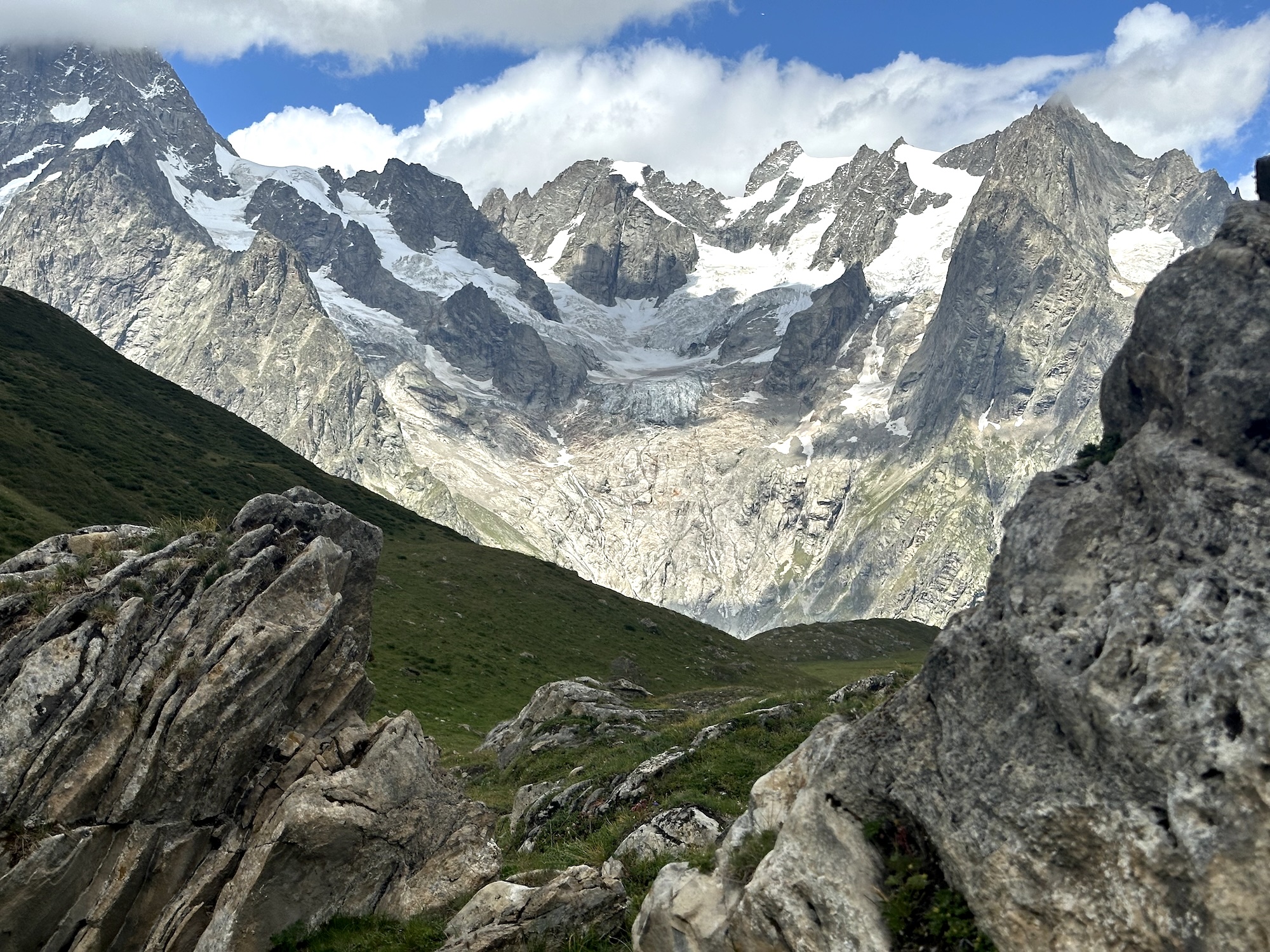
One of my favourite views from day 1 – from the top of Col de Tricot
Breakfast was at 7am. Coffee, cereal, toast, yoghurt, in a communal dining area with a bunch of others who were either starting in Les Houche themselves, or staying over.
We collected our packed lunch from the kitchen, and did the last bit of organising before heading to the start, just above our gîte, on the central Les Houche road. We left a bag, donned ‘the beast’ at the gîte, filled with our travel clothes, and some clean clothes for when we finished.


The first ascent
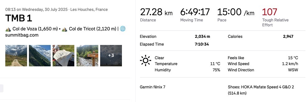
Hiking out, of Les Houche we began the first ascent, slowly making our way up to Col de Tricot (2,120 m). This would be our first significant ‘top’ to reach.
After the initial climb, we reached a forested mountain area (after passing train tracks up), that included some really lovely runnable trail, soon sending us alongside the rock face. An interesting and varied section of trail, shaded in the morning light.
We crossed a suspension bridge, and enjoyed the cool early weather.


After about 16km of hiking and short bursts of running, my IT band on one side started hurting. Unfortunately, this would soon spread to both sides.
I slowed down, and started to worry if I would even be able to complete the entire route, since I was barely 10% done at this stage.


It didn’t feel like long till we arrived at the top of Col de Tricot, a little over 2000m above sea level.
Early lunch at the top and pie at the bottom
Stunning views, and a quick sit down and break to eat a bit of food from my lunch bag, which was a tuna mayonnaise bagette, a cookie, and an apple.
I also put on some sunscreen here since the sun was high now, and I really didn’t want sunburn on day 1.
After a fair bit of descending from Col de Tricot, we reached Le refuge de Miage in de Saint-Gervais. This is a great place to replenish water, and re-fuel. We ordered pie, and had an ice cold coke here.


After this refuge, there is a bit more climbing to do, and then it is a long descent into Les Contamines.
The easy part
After reaching the bottom, you’re welcomed with a fairly long stretch (maybe 5-8km) of pretty flag and easy terrain through the town and resort areas. It’s a chance to relax and breathe in the clean air. Matt and I paired up through this area, enjoying the scenery and chatting away.


Matt remarked the area reminded him of the movie “The Truman Show” with everything seemingly picture perfect.
As the afternoon progressed, we did our final climb of the day up to Refuge De La Balme, our stop for the evening.
The climb up from Les Contamines is very long, and the refuge we stayed at was on the way up to the top of the next significant point on the TMB route. Thankfully, we would stop here, and continue the remaining climb early the next morning.


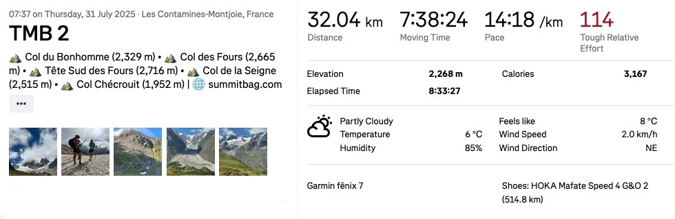
The final figures for day 1 were:
- 27.28 km
- 2036m of elevation gain
- Moving time of 6:49:17
A new day, a new dawn. Day 2
Waking up in my bunk bed, I collected my goods, went outside to the outdoor storage area where we had left our shoes and packs, and readied up.
Breakfast was again at 7am. A routine we closely followed the entire journey. Outside our sleeping area was the dining building. We gathered together, dressed warmly in our synthetic down jackets. It was a cold start.
The spread was coffee, juice, breads with jam, and cereals such as mueseli and granola. George was always first in for coffee, and I was thankful for that, as it meant we usually had first dibs on the coffee pot.
At 7:30am we began our ascent of the remaining climb from 1700m to 2400m.


Here is a 360 degree video showing the area as we worked our way up to the top.
On the previous day we met with a Spanish group (being guided/led by Alta Trek). They happened to be fastpacking the TMB over 5 days too, and their schedule and stops aligned with ours!
Detour (a TMB alternate route)
At 2400m, we stopped for photos, and met this Spanish group again. One of their leads, Annie, mentioned an alternative TMB route at this point was worth taking instead of original planned route.
We pivoted to this route choice, taking in even more climb (a total of 1000m since the start of the morning) to the top of the saddle – Tête Sud des Fours (at 2,716 m). Looking back, this would also happen to be our highest point on the entire route.


It was well worth the detour! We topped off the climb with some snow and ice, took some photos, and chatted with the group, before making our way all the way down again to La Ville des Glaciers.
Lunch in the sun
We stopped for lunch a little further after reaching the bottom, climbing again slightly, and surprise surprise, joined our new Spaniard friends once again.

Now was a sharp-ish climb up to Col de la Seigne at 2500m. There were switchbacks all the way up. Matt and I tackled this section together, with George and Jonny slightly ahead of us.

Surreal flats
At the bottom of the long descent from the top, we found a really bizarre and strangely flat section.
George and I ran much of this section together. Easy miles. We spotted a dog with a snazzy utility pack, which Matt really enjoyed (and who wouldn’t!)


Flats into climbs
Jonny and Matt led ahead in pace, and began the next climb just ahead of George and I.
The next climb of day 2 was the last (3 significant climbs in total). It tooks us to around 2400 meters, before we ascended down to Col Checrouit, which is a ski resort sort of area sitting above the town of Courmayeur.
A video of George hiking up in front of me at some point during day 2
IT band pain again, but those views…
The descent was long and arduous. I fell behind maybe 15 minutes or so due to both my IT bands really hurting. I had started taking Ibuprofen at this stage, which helped me manage the pain.
However, I could still run sections, and made up for lost time by shuffling and running along whenever I could.


Reaching Rifugio Maison Vieille, I ran in with the Spanish group, who were slightly fragmented. It was hot, and late afternoon, around 3 or 4pm.
The refugio had 3 showers, and squatting only toilets (which were a fun first for me!)
Il mio rifugio preferito (My favourite refuge)
I showered and cleaned my clothes with my small bar of soap. We had a really cool, rustic chalet outside, separated from the main building, with 4 x beds (bunks). A laundry line just behind us was perfect to dry our clothes in the breeze.
Dinner was in an amazing old restaurant/bar style building, with old photos and history hung everywhere.
Dinner was glorious. 3 x courses. Pasta with Pomodoro sauce, Roasted pork, and some form of pasta/carb with delicious sauce, followed by a dessert.
A group of young women from California were sitting next to us, and we heard them whispering to eachother in astonishment as they witnessed the four of us ‘heathens’ devouring our food in record time.
We had a massive bowl of the pasta and pomodoro sauce delivered to our table, and before they had even received their own bowl, we had demolished the lot of ours and were already onto the next course.


Final Day 2 stats
- 32km
- 2268m of elevation gain, and roughly the same for descent.
- Moving time of 7:38:24, elapsed time with stops 8:33:27.
Day 3 of Fastpacking the TMB – through Courmayeur we go
The first order of the day was fueling up with breakfast. Again in the lovely dining area, we had tons of granola, cereals, fruit, fruit juices, and of course coffee. We also had yogurts made in Courmayeur.
I think our Californian table neighbours were again astonished at the quantity of foods we were able to collectively consume.
The descent down from the refugio toward town was extremely sharp, and entered a forest with switchback trail. I had actually run this section in reverse (up) last year on our family visit to Courmayeur. There is a swimming pool near the top which our kids loved visiting.
This morning, my IT bands were very unhappy with the descent. Every step was pain, and it took two hours for the pain to dull, helped a little by the Ibuprofen I took with breakfast.


I took the descent down on my own, meeting the guys at the bottom in Courmayeur, where we spent 30 minutes or so doing some shopping for snacks, more Ibuprofen, and looking at a few running and sports shops.
The town of Courmayeur


Up and out of Courmayeur
Climbing out of Courmayeur was another huge ascent. The trail was dry, dusty, and harsh. Lots of chunky rock and crowds of people too.


Near to the top was a refuge which we stopped at for coffee and a water refill. The next bit of climbing was extremely sharp, but I had anticipated it, having ran this section last year too.


After the sharp switchback, the elevation profile reduces to a more sustainable angle, where you can enjoy views to the glaciers on your left, and mountains to the right.
I put on some music, and enjoyed this part in solitude.


Finally I reached the top, Tête de la Tronche, at around 2500m, some hours later. I joined Matt, George, and Jonny for a quick bite of our lunch, where we sat perched on the edge, looking down at the mountains.
Technical section
Next up was an up-and-down section. Chunky loose rock descents, and sharp-ish climbs. Fueled up, we put our heads down and took them on.
I then came across this stunning valley between mountains. The section was quite flat, which I mostly ran, but didn’t hesistate to stop, sit, and admire the view for a few minutes.
The most runnable part of TMB
Soon enough we reached the most ‘runnable’ section of the whole of the TMB route (in my opionion). This is a rolling trail that runs parallel to Val Ferret, the valley above Courmayeur.
It’s an amazing section to make up distance and time, whilst simultaneously being wowed by the stunning glaciers off to your left.
There is another refuge along here, which we stopped at for drinks and a bit of food, plus a water refill.
We ran much of this section, making up good time, closing in on the border between Italy and Switzerland.


A tough climb
The next part was hellish for me. It was an 800m elevation climb up to Grand Col Ferret at around 2550m. However, on the way I found Refuge Elena, where I grabbed a coke and a small souvenier patch for each of us. The other guys forged on ahead, and I sipped on the coke as I slowly my may up.
At the top of Grand Col Ferret was the border into Switzerland. There really are some stunning views up there. It was late in the afternoon now, and I was a bit cold. I decided to slow run the remaining (long) descent to La Fouly, which took another 8km around 1.5 hours.
There were lots of marmots along the trail here, and some trickier descents where I had to watch my footing.


An odd Gîte
Gîte La Léchère was our stop for the night in La Fouly. They had 2 x broken showers, so by the time I rolled in, hot, exhausted, and tired, I had to join the back of a long queue.
I managed a shower just before dinner started at 7pm. The starter was various salads and some breads.
The main course was raclette (melted cheese with boiled potatoes). And it was an onslaught of plates of these over and over, delivered to us until it all ran out.
Desserts were lovely – a large selection we could pick and choose from.
The refuge was really quite odd though. They were older folk running it, and seemed to have some really strange and strict rules.
For example:
- “No WiFi code until everyone has paid!”
- One of the ladies said she didn’t speak English, before explaining all the rules of the refuge to us in English.
- In the morning after everyone was up and about, George turned on a light and an old lady came scuttling over angrily to switch it off again (we needed light in the main area to pack our bags)
However, the older folk were generally quite nice aside from these oddities, and the food was great.
I’ll delve into more details in the specific blog for this day in the future.
PS the WiFi code for Gîte La Léchère is: gite2018 – don’t let their weird WiFi witholding rule mess with you if you’re staying there in future!
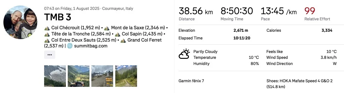
Final stats for the day 3
- 38km of distance
- 2671m elevation gain (a big day)
- Moving time: 8:50:30, elapsed time: 10:11:20.
Day 4, a rainy start, but easier day
Breakfast was granola, mueseli, coffee, and quite enjoyable aside from the angry lady switching off our light!
We ate a lot of breads and jam too, probably not great for the ‘clogging effect’ last night’s raclette spectacle had on our bodies! No toilet time for me it would seem. I wasn’t very regular by this point, even with my augmented all bran breakfasts.
The trails out were a bit of road to start, then muddy and wet slowly descending single track and rocky sections, following a river flowing through the valley.
Fastpacking the TMB implies some running, and this part was amazingly runnable, but my legs were not playing ball. Every step downward hurt like hell. My IT bands were well and truly unhappy. After 2 hours or so, the pain reduced to a mild discomfort on each step.
At this point my mind pretty much canceled out and removed the mild discomfort on each step, unless I specifically focused on it, so this was fine.
Matt and I enjoyed a really quick paced hike along, and soon enough we had already covered 10km.
Toward Champex Lac


The weather turned good again, and we made our way up an amazing forested climb, the next target – Champex Lac.


This climb was shorter than all previous day’s climbs, and winded through lush forest. It was really enjoyable. At the top we emerged into Champex Lac. Where we stopped for a small espresso, warmed our hands next to a fire in the coffee shop, and refilled water.

Leaving Champex Lac for Col de Portalo
Our highest point on day 4 would be Porte à l’Ô/Col de Portalo (at 2,049 m). To get there, we needed to hike up some serious mountain trail. It was really quite overgrown and steep. It was thick forest, and totally different from all the previous day’s biomes.
The start of the forested climb, before the really overgrown section.
We pasted a bit of ice and snow along the way, and finally emerged from the forested tree canopy after sweating it out under cover of tree with no wind to touch us.
At the top the elevation profile eased slightly, and we found ourselves at a busy refuge. It was overcast and cold, so we put our jackets on and enjoyed lunch here.


The chain smoking fan
The descent afterward was fun. George and I ran all the way down. The highlighting moment was being cheered on by a chain-smoking old Japanese man. (He had been smoking profusely at the refuge during lunch).
At the bottom we reached a mountain pass road which we needed to cross.
I instantly recognised this as the top of the pass where my car had broken down (well, the brake pads ran out) last year on my way to the Swiss Alps 100 race. It’s the pass above the town of Martigny.
From here, we continued on dropping down, reaching a cool grated bridge looking over the valley below. The drop got sharper, and we had some fun running down switchbacks and looking for cheeky shortcuts through parts of the switchbacks.
This was a bit of risky move for the ankles, but we had fun anyway.
Finally we reached Refuge Le Peuty in Trient.


We had the afternoon to ourselves, relaxing and chatting at a table outside. We ordered a pizza to share before dinner to start replacing lost calories sooner.
Dinner was in a yurt, and we shared a table with a pair from Singapore, and a group from the UK.
Sleep was terrible at this refuge. The room housed about 25 of us in total, all packed like sardines in a tin. There was an abnormal amount of snoring which kept me awake all night.
Yet worse was still to come…
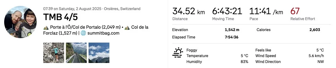
Day 4 total stats
- 34.52km
- 1542m elevation gain
- 6:43:21 moving time
Day 5, the toughest day arrives
At around 4am, everyone started to stir, wake up, and get up. I was confused. Were they all heading off really early?
This day was going to be our longest, and steepest to finish off Fastpacking the TMB. Maybe there was something in that?
No. Everyone was heading for the 2 x toilets downstairs. Stomach trouble. The food from last night. Chicken curry.
I am willing to bet the dastardly staff had used old chicken. 2 of us went down in the first round at 4-5am. Matt and I had trouble starting shortly after we left the refuge and began the first big climb to Col de Balme at 2200m.
Maybe I’ll go into further detail in another post, but we all battled stomach trouble throughout the day. It was relentless. What went in, came out, and we had to keep eating to fuel our difficult day.
Liquid calories in the form of coke really helped, and thankfully there were lots of stops along the way to resupply.
Despite the challenge physically of the day, and the challenge with our stomachs, we joked as we moved through the terrain, making light of the situation.
Big climb 1
The first climb up to Col de Balme was kind of enjoyable actually. Not too steep, though it was a lot – 900 meters or so.


After the climb, there was a slight drop, and then another climb up a bit of a mountain ridge. Following this was a long drop down to the town near Montroc, around 800 meters of height to descend, over 5km.
Views on the ridge just after Col de Balme.
Running down after Col de Balme toward the ridge:
We forced some food and espressos down at the bottom, and I took a blueberry pie which nobody ate, storing for later. (Spoiler alert, I didn’t touch it, and it got mooshed in the bottom of my pack).
Big climb 2
The following climb out of this low point was another huge one. It demanded 1000 meters of vert gain over 6km of distance.


At the top was Lacs des Chéserys. However, the views on the way were amazing. This section included laddered climbs up the rockfaces, and sections of light scrambling. Half way up I stopped at a massive rock pinnacle to watch some rock climbers, and drink another coke. The water loss from stomach troubles now had me slightly dehydrated.


At the top I caught up with the other guys, and sat in a bit of a delirious state, drinking a cola, and eating a bit of my picnic lunch sandwich from the ‘bad refuge’ with long teeth.
There is a photo Matt took of me here which shows the despair I found myself in here. Maybe in the day’s dedicated blog post to come…
Next order of business was a long trail flowing down over really chunky rock toward the gondolas. This section was so busy. The gondolas make it easy for hordes of people to visit, so it was a case of constantly dodging people.
I managed a good run down most of this part, ignoring the IT band discomfort.
However, at our next stop at the main gondola visitor center, I felt my achilles on the right starting to complain. The week’s hard terrain, hills, and probably the last running descent had caught up with me.
I decided with 19km to go, I would need to be cautious now, so it was hiking only from this point.
The trails were stunning though. Some of my favourite views of the entire Tour du Mont Blanc route are from day 5.


Big climb 3
From the gondola station, there was our final climb, around 800 meters more vert over some really rocky and scrambly terrain.
I saw small packs of Ibex here, and met up with a father and son hiking the route over 10 days. My stomach trouble also intensified near the top, forcing a few buckled over darts to the sides.
It felt like the ascent took forever. I let the group go ahead, deciding I would get there late in order to preserve my chance of finishing with shot IT bands and an aching achilles tendon.
Finally I reached the top at around 2400m above sea-level. Now all that remained between me and the finish in Les Houche was 1400 meters of hard descent over 10km.


The BIG descent
It took me a total of 1 hour and 50 minutes from the very top of this point, down to the end in Les Houche.
On the way down my Garmin Fenix watch ran out of battery, so I stopped to charge it and sit on the dirt trail, resting for a bit.
The trail included more ladder climbs, and a lot of chains and rails built into the sides of the rocks. It was actually quite technical in parts, and required full concentration.
With 5km left to go, I picked up my pace again, running where I could. I thought if something goes really wrong with my body at this point, I’ll at least be able to hobble in somehow.
Finally I was down into the town. I walked under the arch we stood in 5 days prior marking our start, and now signifying our completion.
I joined Matt, George, and Jonny for dinner at Gîte Michel Fagot. It was glorious. The feeling of completion, as well as the food.
Afterward we showered, cleaned, and put our used clothes (after cleaning them) in ‘containment bags’. I didn’t sleep well again, but I woke up in the morning keen for breakfast, and a relaxing day sauntering about in Chamonix and relaxing.

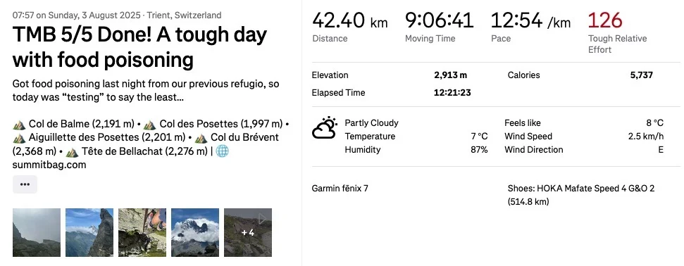
Day 5 stats
- 42km
- 2913 meters of elevation gain, 3100 meters of descent
- 9:06:41 moving time, 12:21:23 elapsed time
- Too many “toilet” stops to count.
Fastpacking the TMB Summary Stats
- Total distance covered: 173.8 km
- Total elevation climbed: 11,430 meters
- Total moving time: 39 hours, 9 minutes
This is going to be a fantastic resource for future TMB hikers – I’m already looking forward to the detailed follow-ups.
I recognise so many moments from my own 8-day TMB last year, Sean, but you blitzed it in just 5! Some of your highlights I know well, others were new to me: different gîtes, alternative routes… and, luckily, you hit the good-weather jackpot. Loved the pie stop at Refuge de Miage, the snow shots, and those scenic detours with the Spanish group. The gîte in La Fouly clearly had personality (and thanks for the WIFI code—vital TMB intel!). Shame about the food poisoning, but you all powered through like true TMB heroes.
You’ve nailed the mix of runnable trails, amazing views, and tough climbs – pain, beauty, and grit in perfect balance.
How’s that IT band holding up?
I wondered how many parts you would recognise from your own TMB adventure last year Catrina!
We were indeed pretty lucky with the weather. Only a few hours of rain on the 4th day. The pies were plentiful in all the refuges. I was suprised. I also stopped at Refuge Elena on day 3 I think it was and got some cool patches/badges for the four of us – they had tons of souveniers.
We had so much fun despite the challenges we all faced. I wasn’t the only one slightly disabled going in 😂
My IT bands are both not right. Definitely a result of the 100 miler last month. I’m working on specific rehab exercises daily to try and sort them out, and will start with reduced running volume next week. For now cycling doesn’t irritate them at all, so I’m happy I can still keep active.
What a brilliant read.
How I found you was searching TMB and CousCous (looking for other campers who found supplies on the trail, which I’m sure every supermarket would stock as part of my TMB (camping route) planning for late August 25)
(Couscous was one of your packed lunches)
And your blog came #1 on google
Unsure how you did 5 days with your IT band problem
I’m not a runner, but was crippled towards the end of 40km hike last year and towards the end was eating Ibruprofen like they were Haribos.
(Orthotics/Podiatrist visit solved everything in my case.
Great photos and looks like a great adventure.
Thanks!
I’m surprised it came up in your search so soon. The couscous was actually really good. The Spanish group that we kept bunny-hopping over each day didn’t enjoy theirs for some reason and at one of the refuges half way through the day we happened to all stop for water/drinks/lunch at the same time and a bunch of them asked us if we wanted theirs.
So we ended up with double couscous portions!
Many of the campsites were near gîtes and refuges, so another option might be to contact those which are close to your planned spots and ask if you’re able to grab food from them? I know the one in Trient that we stopped at had others at our shared table who were camping next door.
It’s great to hear from someone who has had IT band problems too. Mine are improving already, and funnily enough it was a popular hiking youtube channel’s video that had advise and a routine to follow that I used. I’ve been doing the exercises almost daily now (just a 10 minute routine) and have had big improvements already.
After a while the repetitive pain of each step somehow just got ‘lost’ in the back of my mind. I think my stubborness and will to continue on and finish the TMB no matter what somehow tricked it into deprioritising the pain. I know exactly what you mean about eating ibuprofen like haribos. I was slightly concerned as acute kidney injury and cardiovascular problems are associated with NSAID / Ibuprofen use, but since we weren’t pushing too hard each day I was personally ok with the risk.
Best of luck on your TMB adventure later this month. You’re brave to take it on camping, but I’m sure it’ll be really fulfilling. Maybe drop back here if you remember to let me know how it goes. All the best!
Mid September, I completed the TMB in 10 days. Pack with tent, food, stove, fuel etc was 10kg (though without water).
Re reading your post, it’s like “watching my TMB with the fast forward button on x2 speed”
Your day 5 was huge. (I covered roughly that over 3 days).
Thankfully, no IT band issues, but met many people who were suffering similar issues and handed out some spare Ibuprofen I always carry.
Have to admit, I was envious of people carrying smaller packs and staying in huts, though was happy to have my own “sleep space “ in the tent.
I also avoided anything that looked like Curry Chicken!!
You put so much detail into your articles, Sean. I thoroughly enjoyed the read. Your photos and short video clips of panoramas, views and the terrain you were running were amazing. Really cool you kept coming across the Spaniard group who were also fast packing.
Appreciated you listing your detailed gear list. Away from civilization like that no doubt every item would be carefully thought out. To keep everything to 6.7 kg is remarkable.
When all of you had stomach issues on day 5 would have made for such a challenging day. So glad your IT band held up despite much pain and discomfort. Hoping it is recovering well. 🙏
Hi Carl,
Thanks so much for the message. I’m sorry I’m so slow to reply, I’ve been busy in other areas and have neglected checking in on my blog (and other’s blogs!) for a while now.
I’m happy to hear you enjoyed the read and the photos and video clips. Yes, the other group were great, we were all similarly paced, it would have been really cool to have done a large group attempt if we had all known eachother ahead of time.
Pack weight for me was crucial, as about 2 years back I did a fastpacking adventure with a couple of friends, and we each carried 11kg or so. Without having trained moving all day with that weight by the end of day 2 (and including running with the weight) we had all developed issues. So from that point on I have been careful with how much weight I carry.
My ITB issues have subsided. I have done a lot of strength work almost daily since the TMB and so far (after about 4 weeks post TMB) it has not bothered me again. I’ll see how it does on longer runs over 30km and hopefully it is just as robust over longer distance!
I hope you are keeping well otherwise! I need to drop by and and spend some time catching up on your blog. One of these days soon with a hot cup of coffee I look forward to digging in!
You are very welcome, Sean. It is amazing how the extra weight does impact the body. So glad the ITB issues have subsided.