Soon after we planned a trip to South Africa to stay with family in Knysna, and with the idea of leaving the cold and rainy Winter behind in Wales, I began to dream of exploring the mountains in the Western Cape, and specifically tackling the 13 Peaks Challenge.
Finding out about the 13 Peaks Challenge
Years ago I picked up a copy of “Trail Blazer” by Ryan Sandes and Steve Smith on the recommendation of running enthusiast and blogging friend, Catrina over at keeponrunning.net. I highly recommend it to anyone interested in trail and ultra running. Reading about Ryan’s adventures in trail, ultra, and multi-day stage races really struck a chord with me. I love long distance running, especially in adventurous or moutainous regions. Reading the book and digging a bit further, I happened upon the 13 Peaks challenge that Ryan created. Learning about Ryan’s ultra running history also reminded me of my roots. I was born and raised in Pietermaritzburg, South Africa. The Drakensburg mountain range was nearby, and once or twice I remember visiting the Western Cape as a child. I got hooked by the long distance / ultra running scene back in 2017, and the book really resonated with me.
I never got to explore these amazing regions in South Africa by running, as I was never really much of a runner until after I moved to the UK in 2008. Now I live in Pembrokeshire, Wales. We have some pretty spectacular rugged coast path to run, and some epic mountains in the North, but South Africa’s landscape really called out to me now.


Making plans to take on the 13 Peaks
I reached out to the 13 Peaks e-mail to ask if there was any community I could chat with about the challenge. I was keen to see if I could group up with anyone familiar with the mountains and do some ‘recce’ running. To my surprise Ryan responded personally offering to share an Instagram post with my plans. I had no idea he was so close to the challenge website, but as I’ve since found out, he is very passionate about the whole thing. Of course I knew he created the challenge, but he is still very much involved with it even after it has gained a lot of popularity. He even organises badges for anyone completing the challenge (another suprise I only realised once I was out doing the actual challenge itself!)
Ryan shared my post on Instagram announcing my rough plans, and dates I would be in South Africa. Soon enough a couple of people messaged me back. The first one was Danie. A local to the Cape Town area and veteran of the route. He has already completed the challenge around 9 or 10 times. He was very enthusiastic about it all, sharing loads of useful info with me about the route, as well as some slightly tweaked GPX route files.
I started off considering splitting the challenge over two days. Soon however, I thought I would like to have a go at sub-24 hours.
Having now done 13 Peaks, its clear that 24 hours was slightly ambitious for my first try. I would never have achieved that without a support crew in place, and probably not on my first time in these mountains either. Adding the heat we met on the weekend I actually did it would have made 24 hours impossible.
The 13 Peaks Challenge Route
There are 13 peaks to summit, over a total distance of around 107km (66.5 miles). The total elevation gain is around 6700 meters (22,000 feet) according to my final stats.
The peaks (in the order you do them) are:
- Signal Hill
- Lion’s Head
- Maclears Beacon
- Grootkop
- Judas Peak
- Klein Leeu Kop
- Suther Peak
- Chapmans Peak
- Noordhoek Peak
- Muizenberg Peak
- Constantiaberg
- Klassenkop
- Devil’s Peak
Chatting with Danie, and another local, Matt, I planned to join up for a few ‘recce’ runs.
After arriving in the Western Cape (Knysna). Danie messaged to ask if I wanted to join him on a weekend for some sections of the 13 Peaks route. He was planning to do the whole thing himself over a Saturday and Sunday.
Having become a bit apprehensive over the challenge without support, I jumped at the chance to join up with Danie. In fact, I asked if I could join him for the entire route, so I could tick the entire ‘two day’ challenge off.
Knysna to Simon’s Town, and the 13 Peaks Weekend begins
Finishing work off by noon on the Friday, I drove the six hours West to Cape Town. The heat in the car already told me the weekend was going to be a scorcher!
I was lucky to secure accomodation in Simon’s Town with my wife’s sister-in-law’s parents. Arriving at 7pm, I joined them for a quick braai, and then got to bed soon afterward. The plan was to meet Danie in Muizenberg at 4:30am sharp the next morning.
Leaving the car in Muizenberg, I caught a lift with Danie and his partner to Signal Hill where we would begin the challenge just after 5am. Here we met with another of Danie’s friends, Mel who would join us for the first 30km of the route.

We tagged Signal Hill to start the challenge, and starting our watches we set off toward our next target peak, Lion’s Head.
In my Salomon Adv 12 running pack, I carried:
- 2L water + 2 x 500ml water in soft flasks
- Basic medkit
- Storm shell / waterproof layer + merino layer
- Bivvy bag
- A couple bags of sweets, chocolate bars, PH gels, electrolytes
- Black diamond trekking poles in Salomon quiver
- Headtorch to start with
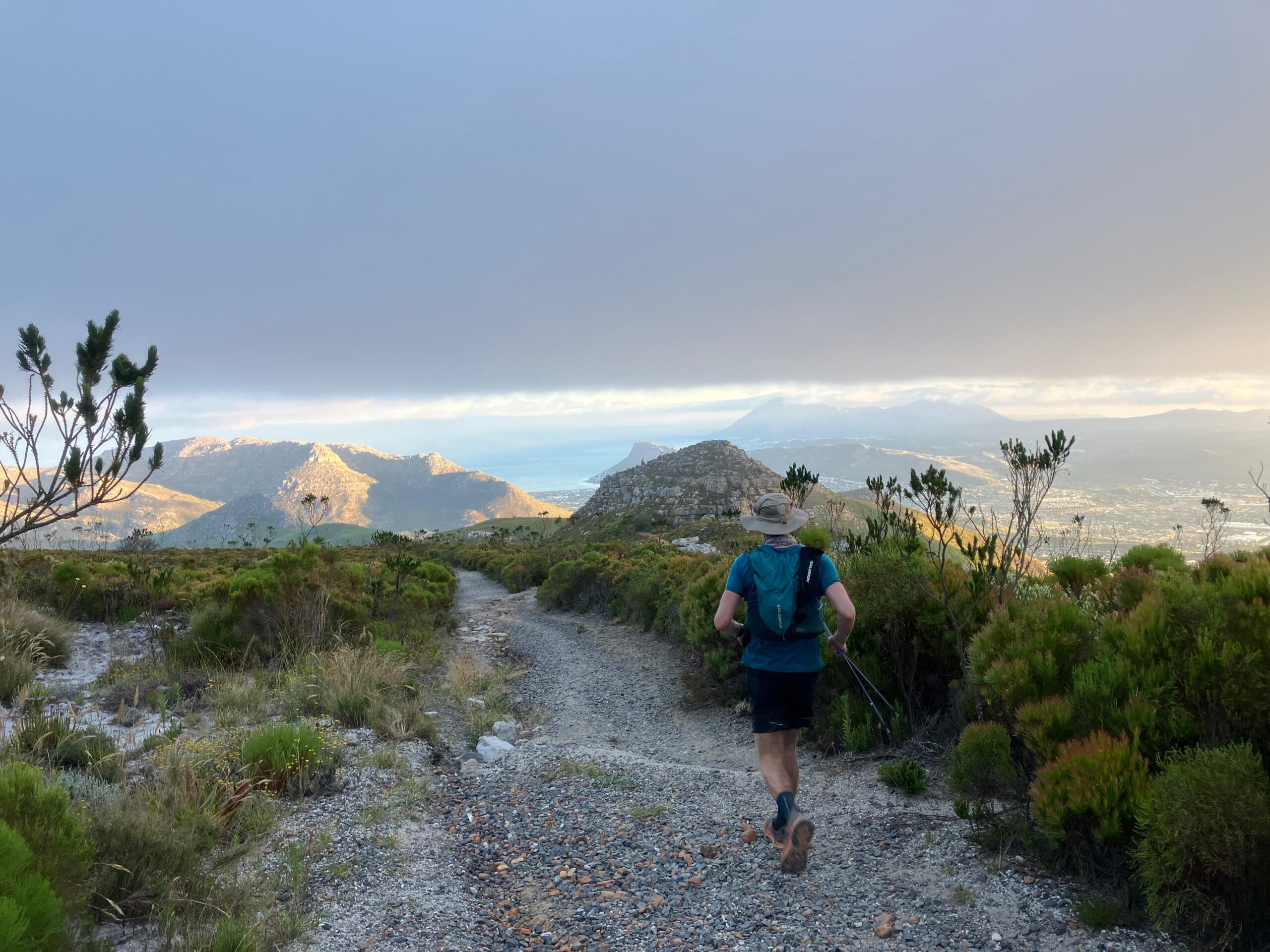
Ticking off the first few mountains of the 13 Peaks Challenge – Signal Hill, Lion’s Head, Maclear’s Beacon, Grootkop.
The initial run off from Signal Hill took us along a bit of road and trail toward Lion’s Head peak. It was still quite dark, so my first few hundred meters were taken carefully as my eyes adjusted.


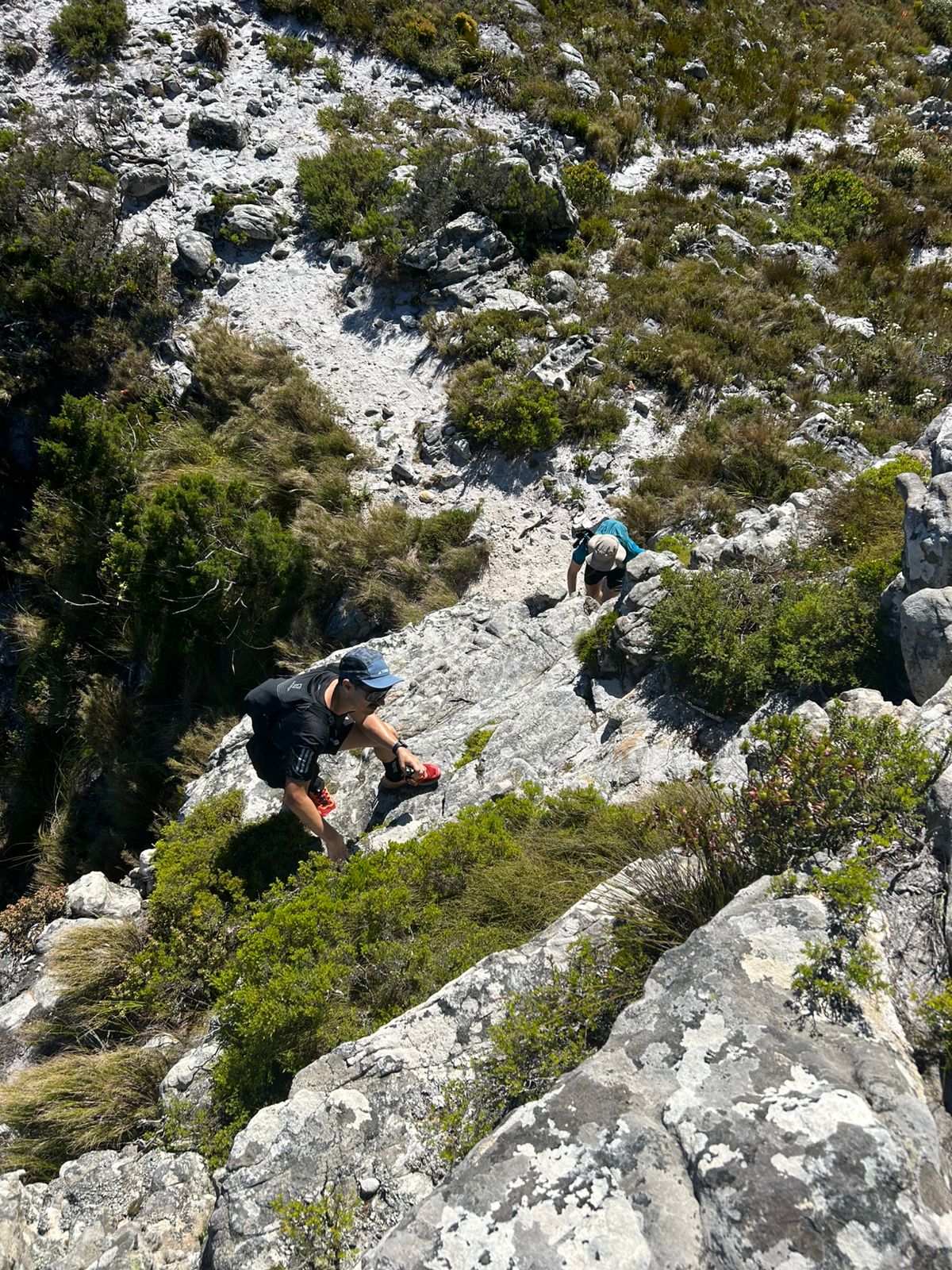
Reaching the trails at the base of Lion’s Head, we kept our pace quick to try and get ahead of the crowds of people that would inevitably be hiking this popular mountain. The trail up is quite rocky and has a bit of technicality in places.
Even in the cool morning air, I was soon dripping sweat everywhere with the incline and speed we were moving. After some switchbacks up, the incline becomes too much for running. At this point you are required to scramble and climb up sections to reach the top.
The route to the top has large slabs of rock to climb up in places, and there are also chains, hand holds, and ladders in some parts to help.
Next up was Maclear’s Beacon. After a short section of road running after Lion’s Head, we reached the trail head up Table Mountain. A long and sustained steep climb up the mountain on mostly rocky steps. At the very top we stopped to get some calories in, and apply sunscreen. The day was set to be a hot one – topping out at about 33-34 degrees celsius.
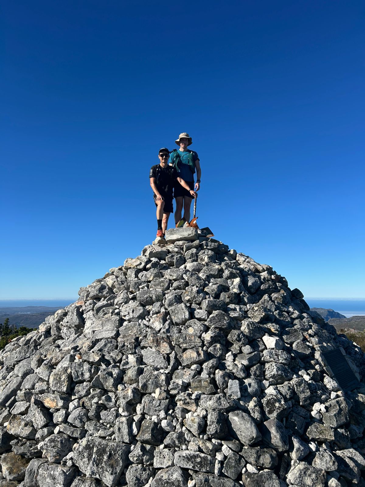
At the top of the mountain we ran across mostly rock slab with some brush, fynbos, and other plants along the edges of the trail. Seeing all of the wild flowers up here was a spectacle to my eyes. I’m not used to this sort of biome back in Wales! The trails along the top of Table Mountain were fairly flat so we could keep a nice flowing pace all the way along until we hit the peak at around 1,086 m – Maclear’s Beacon. It’s a big old pile of rocks forming a massive cairn with the beacon on top.
“Grootkop” (Big Head) was the next mountain / peak to tag at 857 m in elevation. The trail leading toward it is single track, and quite sandy. It made for some brilliant running, and I really enjoyed the run along this part which was interspersed with some light scrambling in parts.

Next up – Judas Peak, Klein Leeukop, Suther Peak
More single track led to Judas Peak. The trail was dotted with these cool odd shaped rocks in places, lots of grass and insects / crickets chirping and tons more wild flowers. A beautiful section to run, but the heat was now beating down on us hard.
It was quite funny to me how during our chats along the way we all discovered we shared a talent in software development / web development. We ended up talking shop along this section about ‘unit testing’ and ORMs (Object Relational Mapping) – two topics in software engineering. The conversation started when Mel asked what I did for a living, and he lit up as he questioned me about the topic. He has been working on his own project. Danie is also an expert in the field and so we were all familiar with the topic at hand.
Mel climbing up some of the trail around this time.
After a bit we tagged Judas Peak with it’s old and rusting beacon at the tip. There were some spectacular views of the surrounding mountains and the coast line below.
There was a bit of a descent down from Judas Peak. The trail was lots of loose, dry, chunky rock. I had to watch my footing quite a bit here.
Short video showing where we descended from Judas’ Peak:
A quick resupply, then onto Klein Leeu’s Kop
After the descent all the way down we reached the edges of Cape Town and came out next to a parking area. Danie’s partner, Tracey met us to refill our water, and supplied us with some much needed ice cold cokes, and a red bull each.
We also met Bridan. Another of Danie’s friends who took over pacing duties from Mel at this point.
We began our ascent up a now very hot landscape toward Klein Leeu’s Kop. (Little Lion’s Head).


Suther Peak hits hard
The next peak I was told was nicknamed ‘Suffer’ peak. After we ascended this in the hottest part of the day (where we also had little to no wind at all), I tend to agree with this name.
It was a slog up there. I felt pretty drained going up. I was also struggling to keep on top of my hydration and I could feel myself getting behind, and I struggled to remember when last I had stopped for a pee.
Bridan, Danie, and I got the peak done though. Only two more left for the day.

Down to Hout Bay to refuel and take on Chapman’s and Noordhoek Peak
We descended down into town. At the bottom we hit a sandy beach trail which filled our shoes with the annoying stuff. Usually I love beaches and sand, but not at this point. I was hot, and my body had pretty much run out of sweat to give. Instead of streaming with sweat, I now just felt overheated.
We ran between some houses, linking up into the town where we passed some shops (Checkers I think). Soon we were at our re-fuel point, a local fuel station with shop.
We spent a good amount of time here – probably about 30 minutes. We refueled with a few drinks each, topped up our water, and had an ice cream.
Ben was next to join us, leaving Bridan behind at this point. I had ordered a hot sandwich, but they took forever to cook it. Eventually exclaiming “vokkit, I’ll leave it behind” (South African lingo starting to flow again after being immersed back in it!)
Chapman’s Peak
We began the long hilly road run up “Chappies” (toward Chapman’s Peak) with Ben now forging the way. It felt like hard work for me. Almost like my legs were wading through treacle. We had around 50km in our legs now, with a significant amount of elevation gained.
Incidentally, Ben had just run the Red Hill Marathon earlier that morning, (having put out an impressive 2:50 or so time for the hilly marathon course!) The fact he was now running ahead of us up Chappies leading the way just blew my mind 🤯
Just before the toll area we heard some car hooting behind us. Looking back it was Bridan who had eventually received our hot food order (after we left the fuel station) and came back to catch us before we left the road to deliver the food. It was great to get some savoury food in, but I couldn’t stomach all of it.
Forcing out some running in the heat was tough at this point. Just as we left the road and joined the trail we stopped for a 5 minute breather and to try cool our core temperature down. Danie and I were both overheating a bit after running up Chappies. My Garmin clocked 34 degrees celsius, and there wasn’t an iota of wind about to cool us down.
Kilometer 48/49 got real slow for me. My upper leg muscles started cramping up pretty badly all of a sudden. Dehydration was setting in. I had watched the muscles slowly start twitching earlier, and I should have recognised the signs and started drinking more. My electrolytes were fine, but I wasn’t getting enough water down.
I had to double down on my trekking pole use and focus every step on lifting myself up the climb to the top of Chapman’s Peak using my shoulders and back muscles instead of my legs. Every now and then my legs seized up completely, similar to the issues I’ve had in the past during the Dragon’s Back race and Ultra-trail Snowdonia in severe heat.
At this point I was almost certain I was going to have to pull the plug on my attempt and bail out. A wave of disappointment washed over me, but Danie and Ben were patient and encouraged me to keep going and drink up.
I hobbled up the last bit to finally summit the peak.

Our first bit of cloud cover had also just moved in as we were getting close to the top. It was a welcome change to the blazing hot sun, providing us a bit of cover and slight reprieve from the heat.
On to Noordhoek Peak
On the way down (it was an out-and-back section) things started to feel better. The load wasn’t on the same muscles, and I think I had just clawed back enough hydration to keep my leg muscles happy-ish. The cloud at the top of Chapman’s had also helped cool me down a bit.
We ran down the same way we came up, rocky technical trail, but easy enough to move quickly down. It felt so good to be covering the same trail so much quicker than the agonising, leg-cramping up I had done just before.
We got to the ‘saddle’ part between the peaks, and started the ascent up to Noordhoek Peak. It was early evening now, so the sun’s heat was no longer as severe.
Having caught up on a bit of hydration was good too. I was confident I could climb the last 400-500 meters of elevation up to Noordhoek Peak from the saddle base without cramp setting in.
With spirits lifted, we chatted away, climbing and making much better time on the last peak of the day. At the top the light diffusing through the cloud cover was pretty spectacular.

We tagged the top, and headed down a jeep track and series of trails all the way till we hit the road.
Here we were collected by Tracey, who delivered us cold beer and delicious pizza.
Soon I was back in Muizenberg. I dropped Ben off near Fishoek where he was staying and continued my drive on to Simon’s Town.
Arriving back at about 7 or 8pm, I joined my hosts for a snack meal of various leftovers from the braai the night before after a quick shower. I was diligent with forcing down as much water as I could, as well as a Precision Hydration 1000 tablet or two.
I managed to pee again thankfully before bed. Checking in on the colour showed things were looking better. I focused on catching some sleep as soon as possible, though an annoying mosquito or two in my room scuppered that plan for the night.
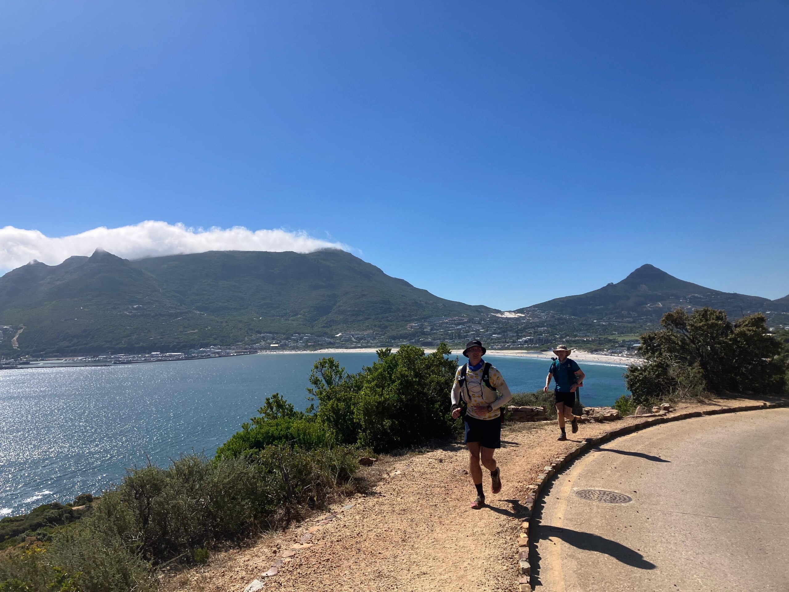
A new day – Muizenberg Peak and Constantiaberg
Up at 3:30am again, for a 4:30am meet-up with Danie in Muizenberg and the early starts were feeling like clockwork already for me.
Coffee, cereal, running kit and gear, 3L of water on board in my 2L and 2 x 500ml soft flasks, and I was ready to go. Sneaking out the house quietly, I drove across to Muizenberg again to park the car there and catch a lift back with Danie to the side of Ou Kaapse Weg (Old Cape Road) where we finished the night before.
We were joined by Nick this early morning. He was going to join the day before, but hadn’t made it, but was up for a full day with us today.

This was an out-and-back section to the top of Muizenberg Peak. The early morning was cool and thankfully a bit windy too. (We had no wind the day before!)
There was great conversation and high spirits. My legs felt pretty decent after a few hours of sleep and I was well hydrated again.
I loved the trails on this section. They were very runnable. Sandy in parts, but only small changes in elevation, and the sand was almost white, making it so easy to spot where I was running, with little interference from brush or bush to the sides.
The last bit up to Muizenberg Peak was a little more technical and rocky, but nothing intense.

Muizenberg Peak felt like the smallest climb of the entire challenge so far. It was nice to tick it off the list, and think in terms of there “only” being another 3 more to go till the end, but I knew that there were two big ones coming.
Constantiaberg
Constantiaberg was next to tackle, at around 928m above sea level. I think I remember the run back entering or skirting the Silvermine area. We also had to enter a SANParks section that required paying an entrance fee for the national park. There was a long uphill road section to run, which was kind of nice in a way. We covered a lot of ground quickly here.
Soon we were on the trail, though at first it was quite easy and still very runnable. There was also a toilet and wash basin area at the start of the trail – a great place to cool off and re-fill water.
The trail ramps up in gradient after this, and in what felt like little to no time, we were already tackling the steepest ascent to the top.
The trail here gets much more technical, and was quite overgrown with lots of sharp brush and bushes to push your legs through.
My shins were already a bit cut up and scuffed from the day before, so this brush in the last 200 meters of climbing Constantiaberg felt like someone taking one of those wire brushes for cleaning your braai (BBQ) grid off to my legs and scrubbing them.
At the top there was massive radio broadcasting building with a tall mast. We passed a few trail runners coming down the way we came up, and shortly after tagged the top.
Coming back down the trail was difficult at first, but after a while we hit road, and were soon flying down, trying to dodge and stay out of the way of various cyclists coming down behind us! It was great to cover a decent amount of distance on the road down hill. Seeing the kilometers tick over faster gave me a psychological boost.
Klassenkop and climbing through trees

The sun was up high now – another hot day. The only reprieve was that there was a very slight bit of breeze every now and then. We had turned off the road and were back on dry and dusty rock trails.
After some pretty technical descending (steep climbs down that needed all fours as some points) and very dusty and dry slippery sand sections, we entered the town area, where the was a market going on at a traffic circle.
Tracey met us here for some support – more red bull, a coffee, and I happily took a half finished sandwich off her hands which I devoured in record time.
We were only around 25km in at this point, but it had been fairly hard work already. I changed into some fresh clothes and also changed from my Hoka Mafate Speed 4 shoes into my comfy wide toe boxed Topo Ultraventure Pro’s.
Changing shoes here suddenly felt like I was starting fresh. We topped up our water, applied new sunscreen, downed some Powerades, and set off to take on the steep climb up toward Klassenkop.
At the top we hit a sort of plateau area, the trail was much more technical, and we had to rock hop a bit over some big rocks, and weave our way through some rock ‘walls’ too.
Danie also explained that many people tend to miss tagging the actual top point of this peak, as it can be a little confusing as to where the highest point is. The video above iluustrates how this can be the case, as once you’re up at the top its sort of all the same elevation, but just with tons of confusing trail between large rocks.
It was a very cool little area. Almost alien-like the way some of the rocks looked with their weird shapes. It reminded me of the Glyderau in Eryri, North Wales (Snowdonia) – though completely different landscapes, both had their own ‘alien like’ looking rock formations.
Then came the interesting tree I had heard about. In order to actually ‘tag’ the peak, there was a crevice which is a bit too wide to jump over, and which drops about 20 meters or so down between the rock.
A tree is sort of growing over the crevice, so you need to grab onto branches and pull yourself over the crevice using the tree as leverage.

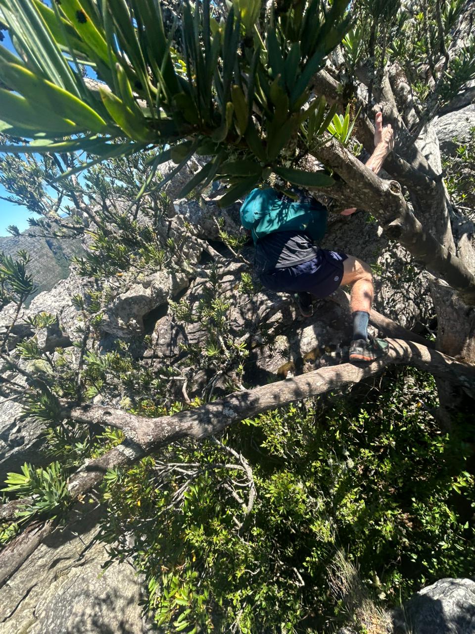


Definitely my favourite peak of the lot I would say!

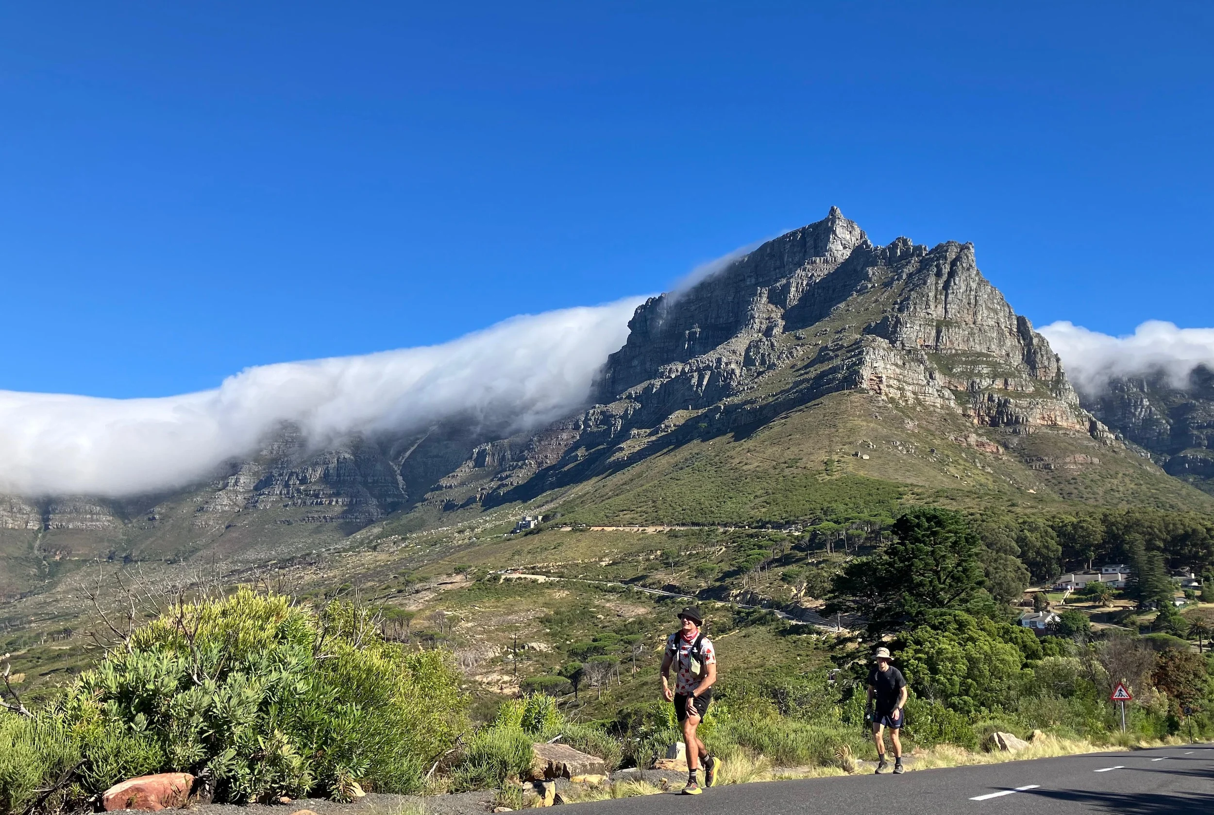
On to the big one – Devil’s Peak
Descending from Klassenkop, we approached Kirstenbosch area. This is the last place I remember visiting in the Western Cape before this trip. In about 2013 we stayed with family in Hout Bay, and I remember we did a hike up Kirstenbosch to the mountains above.
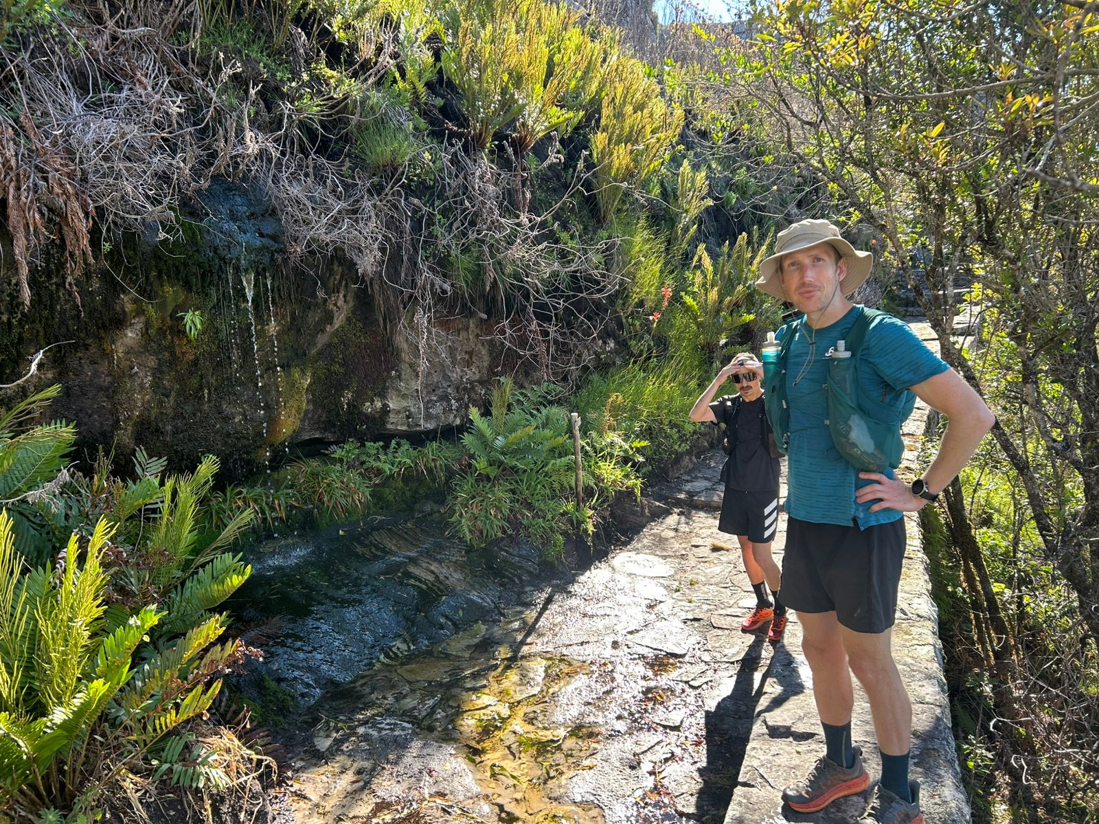
This was a mixed section of trail through bits of forest, and jeep track, with some rivers between. After a while of running we entered the Newlands forest area. It was lovely to get a bit of shade, but truth be told it was out with the sun, but in with the humidity now.
A really nice change of scenery for a while though. We stopped at a couple of river points where the water flowed off the mountain and refilled water / cooled ourselves with water in our hats.
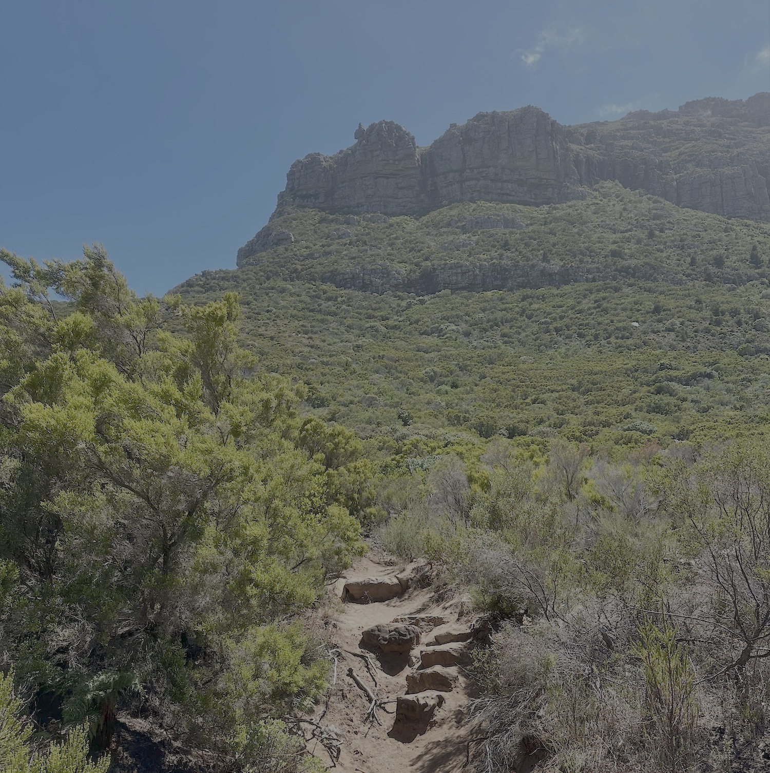
Then began the slow and sweat inducing climb up toward Devil’s Peak, which at it’s top sits at about 1000 meters above sea level.
the climb up was rocky steps most of the way. We saw a few other hikers going up and down. Eventually we reached a bit of a saddle area, which then had us descending a bit down some loose rocky trail, and then back up for the final climb to the peak.
The wind really picked up at this point, and at the top a funnel was blasting air up and over us so hard it was difficult to stand up straight. At least it had a great cooling effect!
Returning to Signal Hill and the Finish
The descent off Devil’s Peak took us back part of the way we had climbed up, but with a diversion at a point to head back down to the road.
There was a long series of switchbacks to navigate down to the road, which were really dusty and dry, with some sections featuring big rocky step-downs.
There was a lack of wind on this side of the mountain and I could feel the early onset of dehydration once again. The end was in sight though – maybe another 8 or 9 kays left at this point to go.
Running down the switch backs I lost focus on one of the step downs, putting too much weight on my foot placement on a sandy step with a bit of angle downward.
Next thing I knew, I lost complete traction and my feet went out from under me, and I fell backward onto the edge of the rocky step. My back hit the edge of the step directly in the middle, but thankfully my medikit and wind/rain shell layer in my Salomon pack cushioned the blow.
It was a bit of a scare because of how I landed, and was the first time I had ‘hit the deck’ all the way along the entire route. Not this close to the end! The last kilometer down I took my time till we hit the road.
Tracey was waiting for the three of us at the bottom, and Ben and also re-joined us today for a bit of running (having run up Devil’s Peak from this side to meet us up top). The four of us spent 10-15 minutes taking on fluids and re-applying sunscreen. My hand was badly bruised from partly taking some of the blow from the fall, and I was covered in dust, but otherwise I was in good spirit. Just all undulating road (about 6-8km) left to go to the end at Signal Hill now!
We all ran in, fighting off the sideways wind that had now picked up. Tracey followed along in the car all the way till we reached the last road climb up to Signal Hill.
The view looking back over Table Mountain:
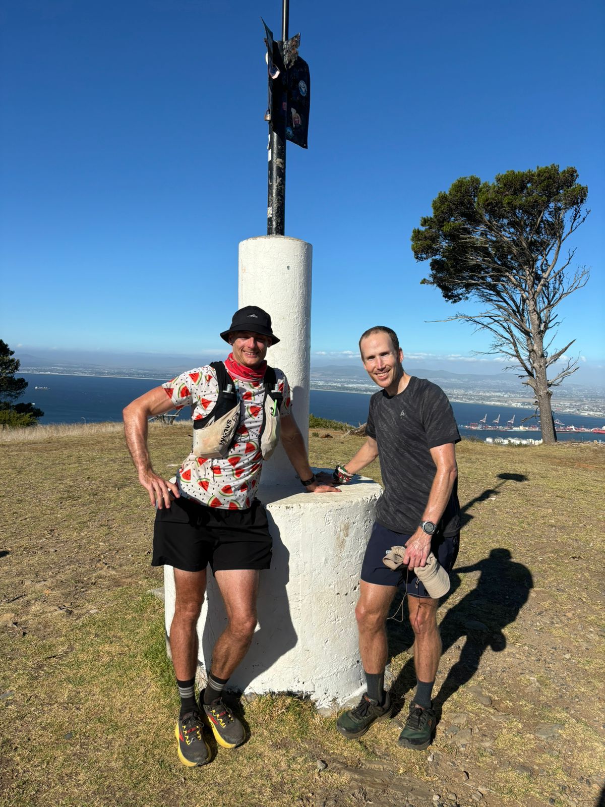
The 13 Peaks Challenge – ‘Two Day’ Complete
It was a special feeling running in to tag the beacon on Signal Hill. We exchanged fist bumps, high fives, and took some photos to mark the end of this epic challenge.
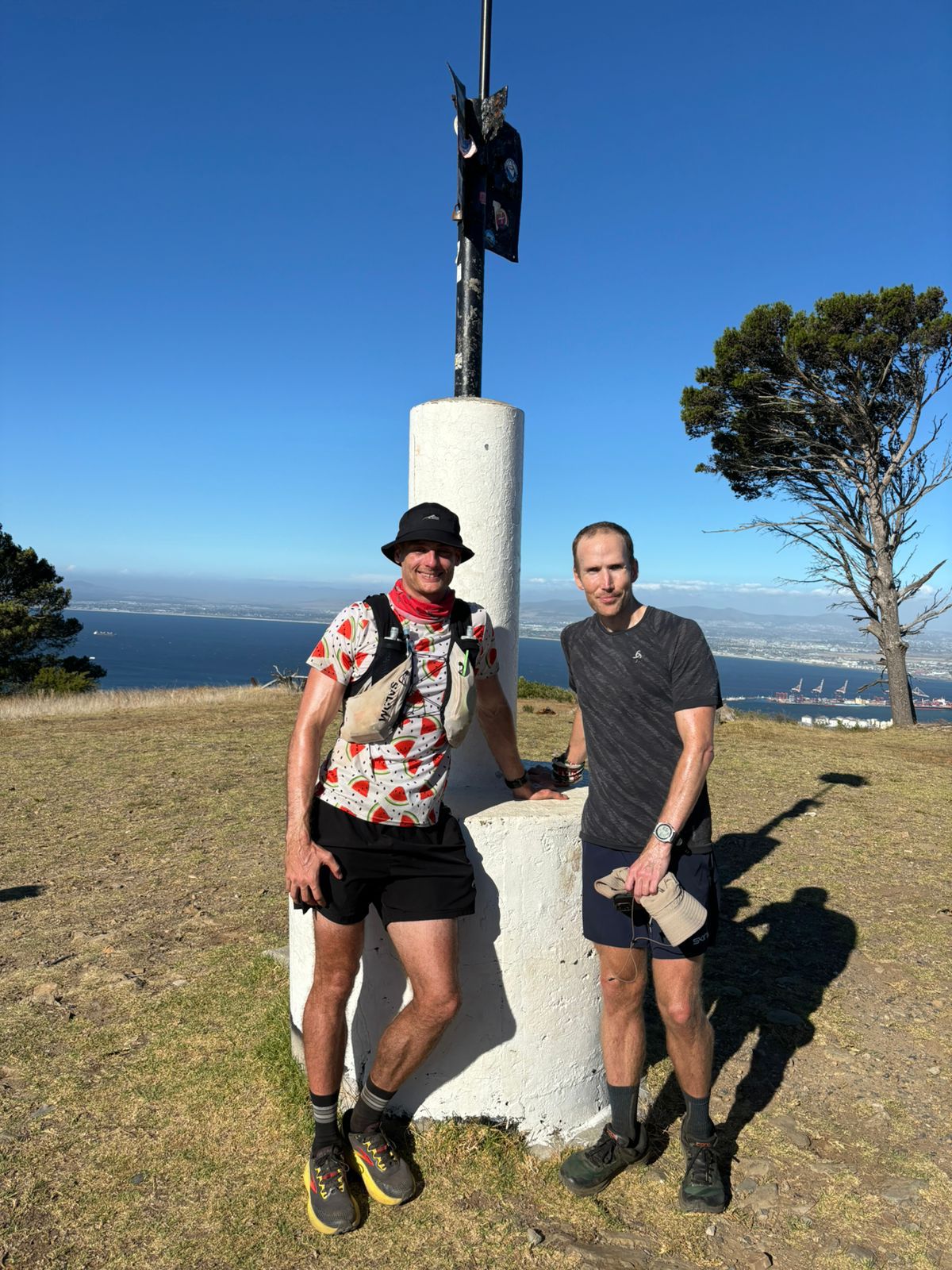
The finishing stats
- 13 Peaks ⛰️✅
- 107km 🏃♂️
- 6700m vert ⬆️
- Time from start: 36 hours (26 moving – 5am starts each morning)
Thanks
I’m really thankful for everyone’s support. Especially to Danie for letting me tag along on his planned two day challenge (one of many he has now completed!)
In addition to Danie, thanks go to his partner, Tracey for driving us to the start and from the end, and topping us up with drinks and food at various support points. What a legend!
Huge thanks to Danie’s friends too – all very talented mountain / trail runners. Notably, Mel, Bridan, Ben, and Nick. Thanks guys!
Also a shoutout to the 13 Peaks community (Danie and Matt for reaching out!).
Thanks to Ryan Sandes for putting together the challenge, motivation, helpful messages, emails, and of course the badges too! He’s very involved in the whole challenge and community, even after its gained so much popularity. It was very cool that he reached out to congratulate us after finishing.
I got my 13 Peaks two day badge (a surprise as I hadn’t thought or even noticed this was a thing until I was out on the trails running the challenge and Danie mentioned the badges)
The next day I finally had a bit of a sleep-in back in Simon’s Town (thanks so much to my hosts Mark and Sarah). It was a relaxing morning having coffee and breakfast, then it was off to sort out an issue on the car that had developed on my drive in from Knysna, before taking the 6 hour drive back to my family again.
Oh wow! Congratulations on this monumental accomplishment!
Tackling the 13 Peaks in 48 hours – especially in that brutal heat – is seriously impressive. Well done for pushing through the exhaustion, Sean!
This was such a gripping read. Does Ryan know you have a blog? He really should add a link to this post on his 13 Peaks page, it’s a great resource for anyone planning the challenge.
And how cool is it that Ryan personally helped you find a team? That’s next-level support! So good that you had Danie and friends along for this wild adventure. Has Danie himself done it in under 24 hours? And Ben jumping in after smashing Red Hill in 2:50…WHAT?! That’s next-level crazy. 🤪
(Incidentally, I got curious and had a look at the Red Hill results. Funny coincidence, but I spotted that Ryan Sandes did the 36 km in 2:55. It looks like he ran with Ashleigh Sandes – if I remember correctly from his book, that’s his sister?)
I loved seeing all the familiar places in your photos! Kai and I did the wimp version of 13 Peaks: we treated it like a long-term hiking expedition, sometimes ticking off two or three peaks at a time, sometimes just one. Klein Leeu Kop was my least favourite (we couldn’t find a decent entry point!), but like you, I loved Klassenkop, climbing through the trees felt very adventurous.
And now, the real question… when are you going for the 24-hour finish? 😈
Thank you Catrina! Yes, Ryan shared a link to this post on the 13 Peaks instagram account. That’s right, Ben mentioned actually that he ran along or nearby Ryan during the Red Hill event. I believe he did the classic with his sister, so you’re right looking at those results!
I just looked up Ben’s exact result – he ran a 2:53 for the marathon. I was more impressed that he joined us on Sunday again (after already having joined us on Saturday after his Marathon!)
You and Kai should apply for the 13 Peaks multi-day badge for having completed the full route yourselves.
I tend to agree about Klein Leeu Kop (or Kleine Leeu kop as you called it!) Although I enjoyed the scrambling up, the start was a bit harsh through the drainage ditch entry way, and the heat during the time we tackled it was severe. This is probably where I lost the most fluids which set me up for muscle cramps later on.